

“How much grass will there be this summer?” This is a question that ranchers, wildlife biologists, range managers, and owners all ponder, particularly when moisture has been less than expected. On the semiarid plains of the United States, where production in a drought year can easily be less than half of average, the answer is not easy. Grass growth is a complex process that hinges on getting the right amount of moisture at the right time. Weather forecasting is challenging, especially for rainfall, so no one knows for sure how much moisture will come until the growing season is over. In the meantime, if signs of drought start to emerge, cattle markets fall, hay markets rise, and rangelands can be damaged in ways that can last for years, or even decades, if we wait too long to reduce livestock forage demand in the hopes that grass will grow. This delayed action has negative effects on the rangeland, as well as the animals, livelihoods, and culture of the people living there.
Grass-Cast was developed to help forecast what grass production might be in the coming growing season. Available online at https://grasscast.unl.edu/, the Grassland Productivity Forecast, or GrassCast for short, is a model that uses soil water holding capacity, plant community, and past weather information to create a current soil water profile. It then takes future temperature and precipitation scenarios to simulate evapotranspiration (ET), available soil water, and resulting plant growth (expressed in pounds per acre near the end of the growing season relative to the long-term average for that local area). The model was developed in 2017 by a large team of research and outreach partners, including the USDA Agricultural Research Service, USDA Natural Resources Conservation Service, Colorado State University, University of Arizona, and the National Drought Mitigation Center at the University of Nebraska-Lincoln.
Because no one knows what the future weather patterns may be, Grass-Cast creates three different precipitation scenarios: below normal, near normal, and above normal. Weather data and corresponding grass production since 1983 (on the plains) and 1985 (in Arizona and New Mexico) are ranked wettest to driest and then split into thirds (driest, near normal, and wettest). Each of the 12 or so years in these three scenarios is then used to fill in future daily rainfall beyond the current date to create total precipitation for the entire growing season. Each of these ~12 “observed + future” precipitation datasets is then fed into a model of soil water conditions and resulting plant growth. The ~12 results are averaged for that scenario, and the process is repeated for the other two scenarios, generating three corresponding projections (forecasts) of aboveground grass biomass (again, think pounds per acre) for below normal, near normal, and above normal precipitation (Hartman et al. 2020). These projections are presented on a map with color-codes ranging from dark blue (at least 30% more than the long-term average production) to dark red (30% less than the long-term average, if not worse) (figures 1 and 2).

Great Plains Grass-Cast maps. The left map is with above average summer moisture, the middle map is with near normal summer moisture, and the right hand map is with below average summer moisture. Colors represent predicted percentage change in grass productions from the 38 year normal. Grey areas either lack sufficient production data or the statistical confidence levels in the forecasts are too low. For more detail, use the zoomable map link on the landing page of the Grass-Cast website.

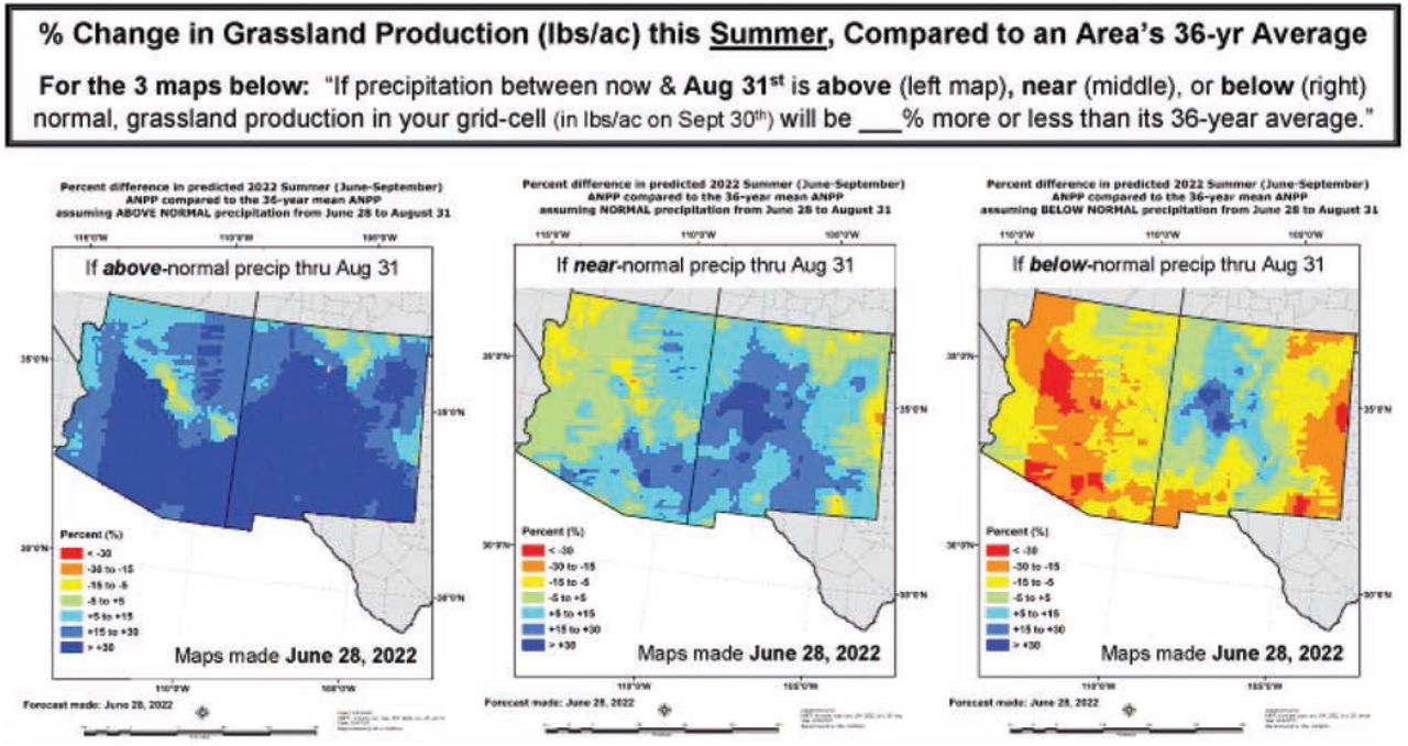
Southwest Grass-Cast map. The left map is with above average summer moisture, the middle map is with near normal summer moisture, and the right hand map is with below average summer moisture. Because the Southwest has distinct spring and summer growing seasons, Grass-Cast also produces two seasons of maps. The summer map is below. Colors represent predicted percentage change in grass productions from the 36 year normal. Grey areas either lack sufficient production data or the statistical confidence levels in the forecasts are too low. For more detail, use the zoomable map link on the landing page of the Grass-Cast website.
Since the forecast is built on 6 × 6 mi (9.7 × 9.7 km) grid-cells, users can use the zoom feature on the Grass-Cast website to get a closer look at a specific area of interest. When a user clicks on a particular grid cell, a pop-up box appears that gives a more precise percentage of expected production relative to the long-term average. New in 2022, the pop-up box also gives information about precipitation received so far compared to the average amount usually received by the map creation date, as well as how much additional precipitation would be needed for the map’s projected amount of forage to grow.
The first maps of the growing season are released in April, but they are highly speculative at that time for both the Great Plains and the Southwest. There just hasn’t been enough moisture or growing season observed yet to know how the season might unfold—almost anything is possible at that time! As more days of observed rainfall are recorded, the biweekly maps become more accurate and useful. By mid to late June, the accuracy ranges from 60% to 80% on the Great Plains (similar calculations have not been done yet for the spring or summer Southwest growing seasons). Knowing this, Grass-Cast maps are particularly useful when paired with field-based knowledge of the timing of grass growth.
Research across the Northern and Central Great Plains has found that grass growth is best predicted by growing season precipitation received 30 days prior to the peak growth period (Smart et al. 2019). This is because both spring (cool season) and summer (warm season) grasses on the short and mixed grass prairie have a point in time where leaf growth peaks and the plants shift to making seed and food storage for the winter. After this shift occurs, the plants will not invest significant energy into leaf growth. For spring grasses, this shift happens in May to early June, whereas summer grasses shift in late June to mid-July, depending on latitude. Thus, the 30-day period prior, when accumulated precipitation matters most, is sometime between April and June 15, depending on the grass species and latitude.
On the other hand, Arizona and New Mexico have distinct spring and summer growing seasons. The spring growing season is driven by winter and early spring precipitation, closing at the end of May. Because spring growth uses all the available soil moisture, the summer growing season relies on June through August precipitation. Grass-Cast creates two corresponding forecasts—a spring forecast and a separate summer forecast—to reflect the two different growing seasons.
Using this knowledge about the relationship between timing of moisture and grass growth, Grass-Cast maps can be a useful planning tool for grazers. Instead of being trapped in a bad situation, the livestock operator is now in (or closer to) the driver’s seat. This is particularly true when all three scenarios (above, near, or below normal precipitation), or even two out of the three, are pointing to major production losses. Small changes to a livestock operation in May or June, in response to information provided by Grass-Cast and other trusted resources, can extend the growing season for the remaining herd and take advantage of more favorable markets. Strategic destocking, early weaning, locating other feed, and other proactive measures can significantly reduce the financial and emotional stress of late summer. Acting early also reduces the risk of over-grazing pastures, which only leads to reduced production in the following years.
DO NOT MISUSE GRASS-CAST
No matter what tool one is using, boots-on-the-ground monitoring and field observations are critical to good drought management. Look down at the range, not across it, to see how much ground is covered with grass, and consider whether that grass is tasty to the animals. Consider what has happened on the land in the last year, last month, and last week. If a rotation strategy is being used, think about how it is working. How long are livestock able to stay in a pasture, compared to what is expected, while still leaving the right amount of grass behind?
Grass-Cast should not be used as a sole source of information when making grazing decisions. Grass-Cast does not know how much moisture fell on a specific piece of range. It doesn’t know if that moisture soaked in, ran off, or evaporated into the air. The model also doesn’t know how healthy the plants are, how tall the grass residue was, if the soil is covered and healthy, or if it blew or washed away. Therefore, Grass-Cast should not be the only information used when setting stocking rates or determining turn in or removal dates for livestock. Additionally, Grass-Cast projects total aboveground production, not grazeable production or grazing loss, so it should not be used directly for documenting grazing losses without doing some additional calculations.
GRASS AND CONSERVATION
What does Grass-Cast have to do with soil and/or water conservation? Grass cover, along with soil crusts in some ecosystems, is the barrier between the soil and wind and water erosion on rangelands. When grass cover falls short, the soil surface is exposed to erosion. Erosion can move soil particles just a few inches, several feet, or miles during dust storms or floods. When soil moves away from the plant, it can leave it “high and dry.” When soil stacks up, it buries the plants. Even if the plants are alive, they will not be as productive as before.
Soils that are covered either by living, deep-rooted plants, or by plant litter absorb more water than bare soil. Water that soaks in and then moves through the soil waters the grass and fills ponds with clean water. Even heavy rains that flow over a healthy, diverse grass stand yield cleaner, slower moving water and better infiltration than land with poor grass cover. Unimpeded overland flow fills ponds with soil and trash, and little water soaks in for the grass to use. Once soil erosion starts on rangeland, it can become a vicious cycle. Healthy, growing plants are needed to protect the soil. Bare soils mean less rain soaks in, and the evaporation rate is higher, so the grasses are struggling and don’t produce enough leaves to cover the soil. New grass plants get beat up by soil blowing or washing over them.
Grass-Cast can give a livestock manager a reasonable expectation of grass production. If it will fall short, they can take steps to reduce forage demand on the range to help keep the system intact.
- Received June 7, 2022.
- © 2022 by the Soil and Water Conservation Society
In this issue


Jump to section
Related Articles
Cited By...
- No citing articles found.